On July 22, a tropical wave emerged off of the African coast centered around 12°N latitude. The wave was the strongest yet for the 2013 Atlantic hurricane season, and begin to organize almost immediately. By July 23, rotation was evident in the satellite presentation, and convection had become more concentrated about the newly-formed low pressure center. Later that day, the disturbance passed south of the Cape Verde Islands, bringing some scattered showers to the southernmost islands. The definition of the circulation improved further during the evening and thunderstorm activity persisted, so the low was upgraded to Tropical Depression Four early on July 24.
Later that morning, as the system moved west-northwest, it organized further, and strengthened into Tropical Storm Dorian. The storm was entering less favorable conditions, including the slightly cooler water of the central Atlantic and a large dry air mass to the northwest, but the effect of these factors was partially neutralized by a warm, moist air flow that continued into Dorian from the south. Over the next day, therefore, the tropical storm was still able to improve in outflow and convective organization, allowing it to intensify into a strong tropical storm by early on July 25.
Late that day, a large burst of convection flared up, and Dorian even exhibited a clouded eye briefly, reaching its peak intensity of 60 mph winds and a pressure of 999 mb. However, even though the system was now moving into warmer waters, it lost its equatorial inflow of moist air, and the circulation was largely at the mercy of the large dry air mass to its west. This dry air, coupled with moderate shear out of the southwest, disrupted the circulation during the evening of July 25, and Dorian became much less organized. The storm weakened into July 26, and meanwhile continued to race west-northwest, as a ridge to its north steered the shallower circulation faster than it had the previous day, when Dorian had been stronger.
Later that day, Dorian made a turn more toward the west and moved even faster. The circulation became totally exposed that evening as nearly all convection disappeared from the system. It was unclear whether Dorian was still a tropical system overnight, but some thunderstorm activity did redevelop during the early morning hours of July 27, prompting the National Hurricane Center to continue issuing advisories on the weak tropical storm. However, the wind shear had now increased to such a degree that it was eroding the circulation, and it became clear during the afternoon of the same day that Dorian's circulation was no longer closed and that it had degenerated into a tropical wave.
The remnants of Dorain continued west-northwestward and continued to produce gale force winds and convection. However, though a swirl in the clouds was evident, this was not due to a closed surface circulation, but to an upper-level low in association with the system. Thus, despite the fact that the disturbance was no longer a tropical cyclone, the north coasts of Puerto Rico and Hispaniola experienced high surf as the system continued to move west-northwestward. The moisture that had been part of Dorian began to spread over the Bahamas on July 31, and conditions improved as shear lessened. On August 1, more convection appeared and surface pressures fell near the western Bahamas during that day.
By August 2, a trough of low pressure was evident, but the system did not yet have a closed circulation. As the western edge of the system brushed Florida, the remnants of Dorian triggered showers and thunderstorms over various parts of the state. However, the low turned northward that day, navigating around the edge of the Bermuda High. Overnight, despite the fact that upper-level winds were again increasing, a closed circulation appeared, indicating that Dorian had reformed into a tropical depression. By the morning of August 3, convection was displaced well southwest of the center of circulation. But Dorian persisted after its reformation for only 12 hours, reaching only tropical depression intensity and degenerating into a remnant low by the afternoon. The low was absorbed by a frontal boundary the next day.
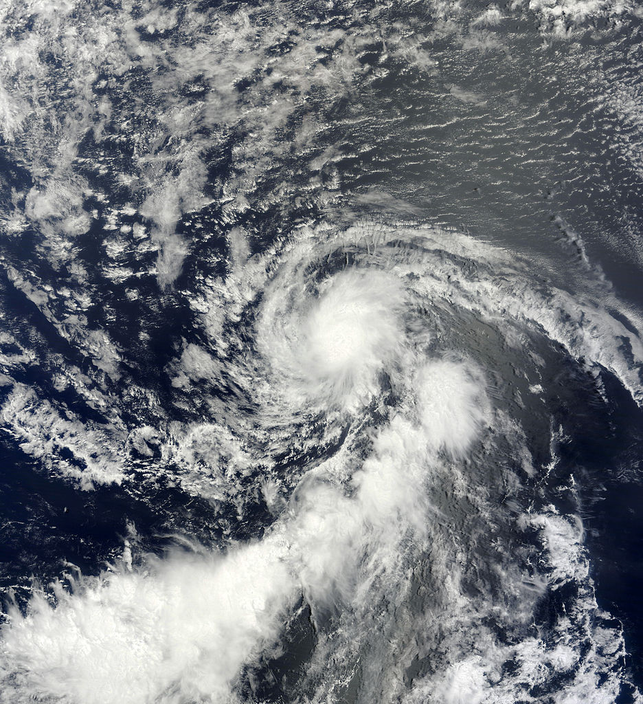
Dorian was afflicted by dry air for most of its lifetime. The above image shows the western half of the circulation to be partially exposed due to the same dry air, even though Dorian is near its peak intensity.

Before reforming on August 3, Dorian had for a time been only a tropical wave, with no associated low pressure center.
2 comments:
Cool!
Dorian was afflicted by dry air for most of its lifetime. The above image shows the western half of the circulation to be partially exposed due to the same dry air, even though Dorian is near its peak intensity.
Gold für WOW
Gold für World of Warcraft
Post a Comment